
 Hallwilersee is a small lake north of Luzern and south of Aargau.
You could spend a full day looping around the lake. We put the kayaks in on the small stream that feeds into the lake at the north end. This location provides free parking, easy access and a convenient dock for the kayaks.
(click on image above to enlarge)
Here are the map coordinates for where I parked.
Latitude: 47°19'10.64"N
Longitude: 8°11'49.12"E
Google map link
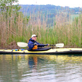
Pros: The northern end of the lake is a protected nature area with a large number of birds. I found this area the most interesting. Keep a good distance from the coastline when there is a protected nature area. Often there are signs saying how far to keep from the shoreline.
Cons: Can't think of any negatives. Be sure to keep your distance from the swans and their nesting area as they can become aggressive toward a kayaker.
Closing comments: Halfway along the eastern shoreline (Meisterschwanden) there is a weather warning light viewable from any location on the lake. I marked the light's location on the above map with a yellow dot. These lights are very important for boaters in Switzerland as weather can change suddenly and without warning.
40 flashes per minute = There is a possibility of high winds (25-30 knots).
90 flashes per minute = High winds (34 knots and above) and you need to get off the lake now.
Get out of the water no matter how nice the weather appears at that moment! The day we were there it was flashing 40x/min. and the water was choppy. This is one of the reasons we didn't get very far on the lake.
Photo album: with descriptions and locations of photos marked on map.
 |
| Hallwilersee (kayaking) |
Hi, thanks so much for the insightful posts. Are you still kayaking?
ReplyDelete