Vierwaldstättersee is sometimes referred to as
Lake Luzern in English.
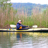
Date of trip: July 2005
The kayak was put in near the far end of
Alpnachersee and I kept mostly to the shoreline passing by
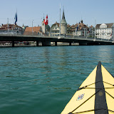
Hergiswil (the glass factory/museum is worth visiting) with Pilatus rising in the background. I continued to Luzern, paddled around there a bit before returning the same route. Length of time kayaking on the lake was from 10am to 6pm. I look forward to returning again to explore the other end of the lake.
Pros: You are at the foot of the alps so the view of the mountains is spectacular. You also have the option of seeing the beautiful city of Luzern from a different angle. There was plenty of room to avoid fishermen and motor/sail boats on the lake. The Swiss boaters are generally very polite and considerate of others on the water. You could easily spend several days exploring the coastline and many inlets. The wind and choppy water didn't seem as strong as other lakes of this size. This could be partly due to being nestled between the high surrounding mountains.
Cons: It was difficult for me to find a parking place and entry point where I could legally
and conveniently put the kayak in. Much of the ideal coastline seemed to be private property, private boat docks & clubs, restricted areas, inaccessible by car, etc.. Places to put in do exist and I will let you know what I find when I return to the lake again.
I had to keep an eye out for the large sightseeing boats – to stay out of their set route (picking up passengers at locations around the lake) and also not get caught off guard with a broadside from their wakes. This could be a positive point if you like a bit of excitement along the way. ;-) I mostly kept near the shoreline and a safe distance from the larger boats – one of the reasons I bought a highly visible bright yellow kayak!
Closing comments: Be careful to observe restricted areas – marked off swimming areas, boating restrictions around the bridges in Luzern, and a few restricted nature preserve areas you need to keep your distance from. The Swiss abide by and enforce the rules (which is a good). I had a visit from the Luzern police boat when I cut on the inside corner of the swim area marker (by a foot). I knew better but was making a quick maneuver to avoid the wake of a fast moving boat coming toward me. Considering the situation, I got off with a warning.
Here are the map coordinates for where I parked (free) and put the kayak in.
Latitude:
46°57'58.47"N
Longitude:
8°17'38.90"E
Google maps link
Photo Album with
descriptions and
photo locations marked on Google map.


 Hallwilersee is a small lake north of Luzern and south of Aargau.